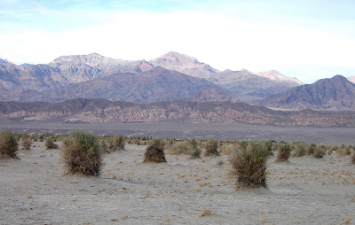
The pictures below were taken nearing sunset, toward the end of our visit to Death Valley. The next day, all day, we drove home. The dunes are the Stovepipe Wells Sand Dunes, about 2 miles from our motel.

The deciduous bush is Honey Mesquite, the pods of which were used by Indians to make tea, syrup, and pinole, while the green blush is creosote. Besides these, there are small bits of tumbleweed and a few patches of rabbit bush. In other parts of Death Valley we saw some desert holly and a few flowers.

Dried mud.

Garrett and Evan were rolling down the dunes. As you can see from the footprints, Death Valley over Presidents Day was popular. The further from the road, the fewer footprints, though a number continue on. The next windstorm will clean them out but, in the 21st Century when Mt. Everest and Antarctica are regular destinations, it's a bit silly to pretend visit a pristine landscape.

The dunes are deep and cover a large area.

The sun is nearly gone.

It's been a comparatively dry winter in Death Valley, given that annual rainfall averages 2 inches, though rain was expected after we left. Anyway, there were a few daisylike plants.

More wildflowers. The white stuff is salt, not water.

The Devil's Corn Field. Those are arrowwood bushes building dunes and soil for their roots.

We ran up the short path to the overlook and took these pictures, the top one to the east and the bottom one to the west, then walked partway down the lower trail. Zabriskie Point is north and east of Artists Palette, and was formed from lake sediments and ash, later squeezed and tilted from land movement. Except for a bit of desert holly on the trail, nothing grows here.


Heading north from Badwater Basin, we detoured onto Artist's Drive, stopping at an overlook. The picture below is from partway up, looking back toward Badwater Basin.

In the opposite direction, the picture below looks toward the end of the overlook.

From the top. The sun was intense and hats helped. Walter records my Annie Hall look.

We took a break at the top.

Back on the road.


Coloration comes from minerals, clays, and volcanic deposits.


Heading toward Stovepipe Wells from Badwater Lake, we stopped by the Devil's Golf Course. The field is essentially a 3rd grade science project gone mutant. Seriously. According to the USGS, about 95% of what you see is crystallized table salt.

Hopefully any fool stumbling into this, especially one with a wagon, horse, or donkey, would decide to move on and go around.

From our motel we drove to Badwater Lake, which has the lowest land in the western hemisphere. What you see on the ground is water, and lots of table salt. The white stuff on top the mountain peaks, though, is snow.

The salt is so white it looks like snow. But it's warm, and the air is so dry you feel it suck the moisture from your skin. Below is the sign stating that the ground is 282 feet below sea level.

Looking north, toward the Devil's Golf Course. The lake that used to be here ran north and south.

Water is either on the surface or just below the surface. But the truth is that water can be found anywhere in Death Valley by digging. The water tends to be salty, but there's plenty for showering and drinking. The motels have swimming pools.

The block of white letters on the side of the mountain below marks sea level, 282 feet above the ground.

We didn't look closely but, according to park experts a "tiny Badwater snail manages to survive in the salty water and a few plants--pickleweed, salt grass, iodine bush" live next to the water.

The white stuff looks like snow even after clicking on a picture for a larger view.

Going places in California means going over, through, or around mountain ranges. Most trips include stretches of two lane, twisting roads with no or few trees to block 'scenic' views. The gut wrenching part of this particular trip was taken by a couple of thankfully short stretches on Highway 190 between Olancha and Stovepipe Wells. The picture below was taken as we descended from the last few comparatively gentle turns into Death Valley.

After checking in to our motel, we took a short walk. This sign sits just off the road going past Stovepipe Wells. It's worth recalling that most of Death Valley is below sea level. To the left of the sign is the moon. At night it shone brightly enough to block multitudes of stars we had hoped to see.

This looks past the sign to Stovepipe Wells. Our motel room is in the building on the far left.

We walked toward the mountains seen behind our motel above. Looking toward the horizon below, you can see our motel and Stovepipe Wells. In the direction we walked it looked just as you see, sloping upward toward the mountains. Landscape features are formed by runoff. Though it doesn't rain much, when it rains water flows quickly.

On the way to Death Valley, we stopped atRed Rock Canyon State Park long enough to get out of the car and take a few pictures.


Subscribe to:
Comments (Atom)


